Case study · Conservation
Where a highly threatened fruit bat finds its food
Only about 1,500 Livingstone's fruit bats remain, on two islands of the Comoros. GPS and acceleration data, annotated with FireSOM, revealed where they feed, and which landscapes conservation has to protect.
Known roosts, unknown feeding grounds
Livingstone's fruit bat lives on just two islands of the Union of the Comoros, and with only about 1,500 mature individuals left it is one of the most endangered fruit bats in the world. Most of them live on Anjouan, where only around 10% of the island is still covered by forest, and the bats depend on it.
The roosts where the bats rest are known and surveyed regularly. What was missing was where they find their food. Without that, feeding areas could not be part of the conservation effort that is meant to keep the species alive.
A GPS fix every 90 seconds on the move
The team caught bats weighing more than 400 g, so that the 15 g solar-powered GPS tag stayed below 5% of their body weight, and fitted the tags on collars designed to drop off after four to six months. Seventeen of the bats delivered enough data for the analysis.
The tags recorded a GPS position every 90 seconds while a bat was on the move and every six hours while it rested. Acceleration was recorded for four seconds every minute on all three axes, giving insight into the bats' behaviour even when no GPS position was available. The data were downloaded by radio from the roosts several times a week.
From a pilot to a programme
The approach goes back to a pilot study by the same lead author. In early 2019, two bats were tagged on Anjouan, and for the first time quantitative behavioural data were collected for the species (Mandl et al., 2021, Oryx). Back then, behaviour was classified from the three acceleration axes in the Movebank Acceleration Viewer, Firetail's predecessor, and feeding sites were located by clustering the matching GPS points. The 2025 study follows the same idea, with 17 bats and an automated classification in Firetail.
Where Firetail came in
A GPS position alone doesn't tell you whether a bat is feeding. The acceleration data do. The team used the FireSOM algorithm in Firetail to sort every acceleration burst into categories, based on the statistics of the three axes and the overall dynamic body acceleration. They then validated the categories by hand and matched them to behaviour, using field and zoo observations in which three tagged bats were watched and compared with their acceleration data.
This way, every GPS point could be annotated as flying, resting or moving/climbing. Moving/climbing was the only category in which GPS points could have been recorded while a bat was feeding, so these points marked the potential feeding locations, which the team then clustered in R.
Likely feeding where the trees are
- Home ranges averaged about 12 km² for both females and males, from under 1 km² to almost 48 km².
- The bats travelled about 4 km in the daytime and at night alike, more daytime movement than closely related species show. The authors suggest this may come from the lack of predators and the need to find enough food in a heavily degraded landscape.
- The potential feeding sites lay mainly in landscapes with many trees: around 55% forest and 35% agroforest, with about 10% agricultural land and almost no settlements. Three bats fed almost exclusively in forest.
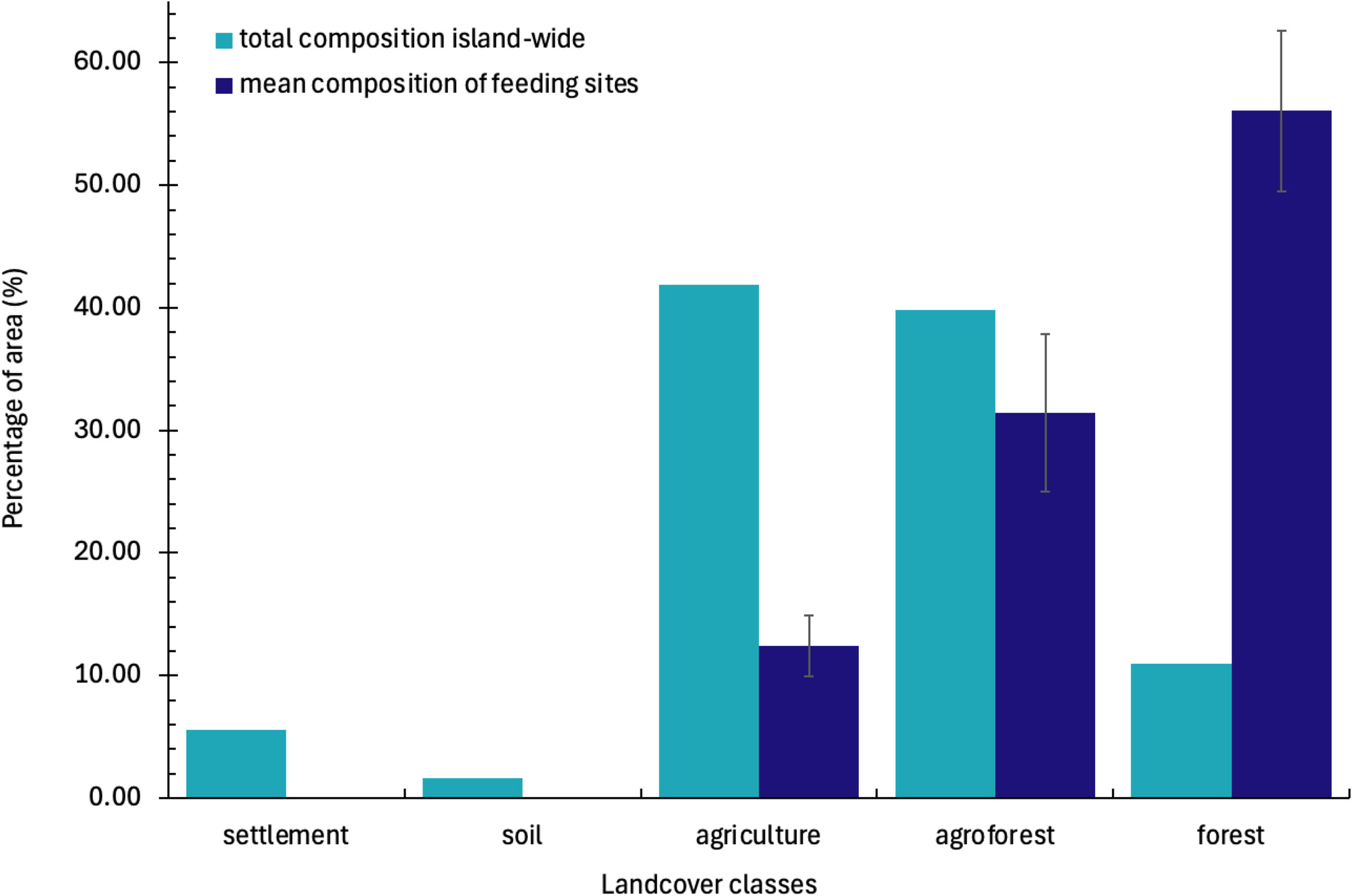
Land cover of the whole island (light blue) compared with the mean of the 238 potential feeding sites (dark blue). Figure 3 from Mandl et al. (2025), Conservation Science and Practice, licensed under CC BY 4.0.
The results will be integrated into a landscape-wide conservation programme that a local conservation organisation runs together with the communities on Anjouan, to make sure the resources the bats depend on are protected.
“Firetail provides me with exactly the sort of data analysis tools I need. It is a pioneer in dealing with modern GPS datasets”
This story is based on the publication listed here. Are you one of the authors and would like to add something or correct us? Get in touch, we'd love to tell the story in your words.
Get Firetail
free downloadGet started with Firetail today! Interactively process high-density data for multi-animal, multi-year projects!
“No risk: request a three-month trial, kickstart your analysis and see your data in an all-new light!”